Driving from Narrabri township to the observatory

When travelling from the town to the observatory, there are two paths to follow at first, depending on whether you are approaching from the town centre or from the southern outskirts of the town.
Driving from Narrabri township to Narrabri Observatory Maps - OpenStreetMap
- When travelling from the south: You reach the outskirts of Narrabri (either from Coonabarabran or Gunnedah) at a large roundabout. Continue on towards the town proper crossing a railway track and then arriving at another large roundabout. Here you turn left (away from Narrabri) into Mooloobar Street and on your right hand side the Narrabri Lake will come into view. Keep travelling along Mooloobar Street until you come to a T-Intersection and turn right into Baranbar Street (following the Australia Telescope sign). Turn left at the next T-intersection into Goobar Street.
- When travelling from the town centre: Leaving the town centre heading south towards Sydney or Coonabarabran, you cross the main river flow (Narrabri Creek) and then the old dry riverbed of the Namoi River. Shortly afterwards follow the signs to "Australia Telescope" turning right (Ugoa St), left around the Narrabri Lake (Walowa St), and then right again at the Wilga Hotel (Goobar St)
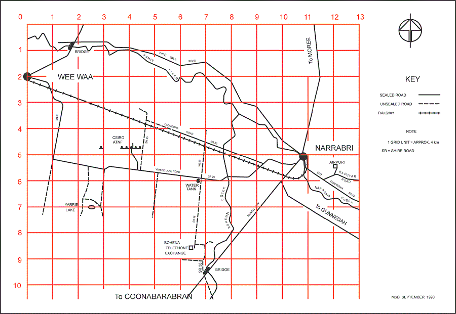
Continue along Goobar St - which changes into Yarrie Lake Rd - keep going west, past the large Cargill cottonseed oil factory on your left, crossing a railway track and the usually dry Bohena Ck. About 20km from town there is a sign directing you right to the "Australia Telescope". Follow this tarred road 2km, and you are there. The Observers' Lodge is the first building that you come to, on your left. Continue straight through a five-way intersection to go to the Visitors Centre. Turn left at the five-way intersection to go to the Control Building.
Warning! There are often kangaroos and sheep grazing on the site: please drive carefully, particularly approaching dawn and dusk. Headlights dazzle kangaroos (and other animals), but they tend to react less suicidally if you `dip' the headlights when approaching them. During and after rain there are a series of causeways/floodways which can become quite deep. Please slow down and cross with care.
For more information, see the maps of the Narrabri district and of Narrabri township. A sketch shows the most important roads more clearly (also available in pdf). Also see the maps of the site and central area.
Original: Penny Nelson (1990)
Modified: Brett Lennon (29 Feb 2016)
